Advanced Aerial Surveying, Photography, and Videography
Ohio Aerial Observation Solutions
Columbus Helicopter Charters offers comprehensive aerial survey solutions throughout Ohio, encompassing advanced applications such as magnetometer and electromagnetic surveys, LiDAR data acquisition, and precise GIS mapping. The inherent low-altitude flight and stable hover capabilities of helicopters are optimally leveraged to ensure exceptional data fidelity and coverage for critical infrastructure assessment and environmental analysis across the state. Furthermore, we provide specialized aerial filming services, enabling access to state-of-the-art cinematography and photography platforms, including options for door-off operations to facilitate specialized handheld camera work. We deliver tailored aerial perspectives designed to meet rigorous technical specifications for diverse project requirements across Ohio's varied terrain.
Aerial
Surveys
LiDAR, GIS Maps, FLIR, HD Video & More
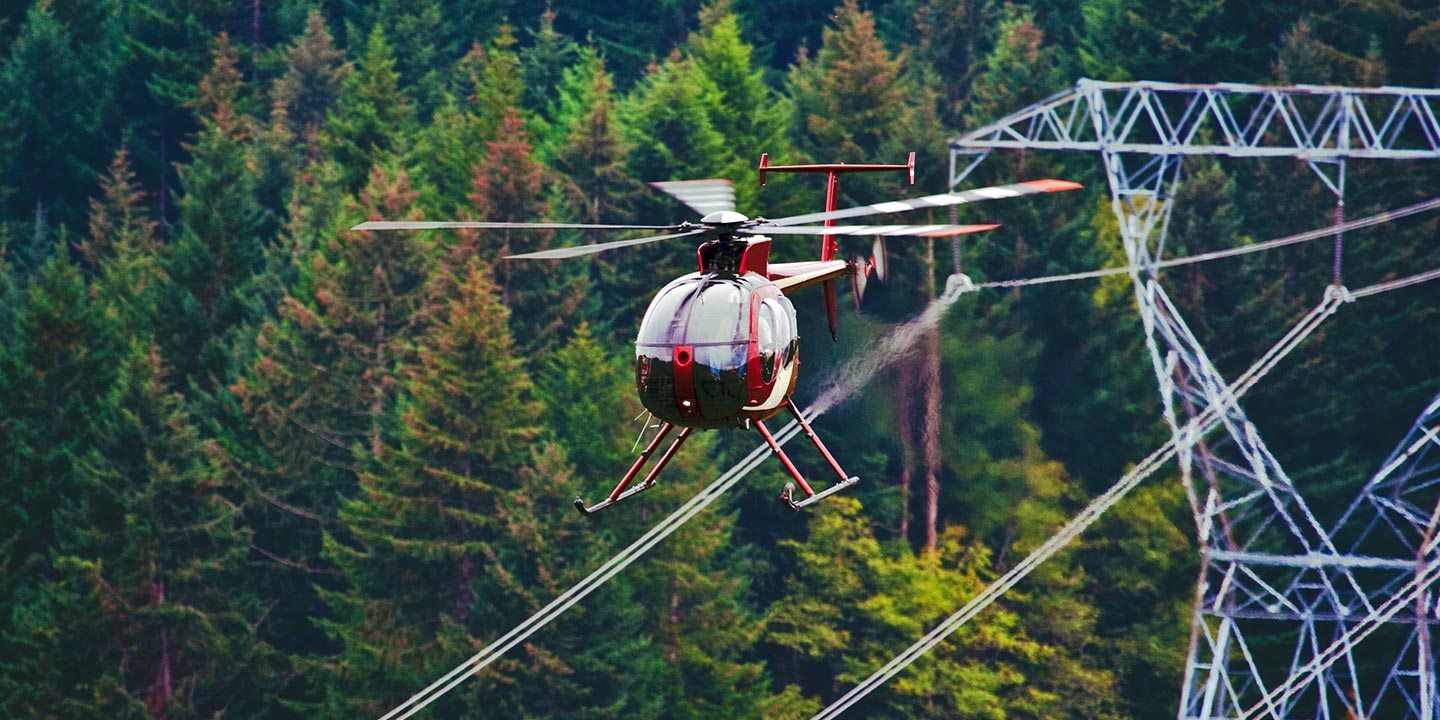
For essential infrastructure integrity assessments across Ohio, Columbus Helicopter Charters facilitates precise pipeline surveys, comprehensive Right-of-Way (ROW) inspections, and critical transmission line patrols. We ensure access to appropriately configured aircraft, specialized sensor packages, and experienced flight crews adept at these technical operations, guaranteeing project execution with accuracy and adherence to strict compliance standards.
High Tech Results
The Top Pilots in Ohio, Today's Technology... Maximum Results.
Call 1-866-826-4826 Now!
Columbus Helicopter Charters provides the tools needed to complete your land surveys, utilizing the right equipment to provide the aerial photos that are often needed.
Precision aerial surveys are instrumental in streamlining Right-of-Way (ROW) and site inspections, comprehensive topographical data gathering, and high-definition photographic documentation for critical commercial and infrastructure projects throughout Ohio. Helicopter-based surveys provide an unparalleled vantage for meticulously examining Ohio's diverse terrain, identifying pipeline anomalies, assessing transmission line integrity, and acquiring detailed visual data of properties. Columbus Helicopter Charters specializes in developing custom photographic and remote sensing operational plans, meticulously tailored to optimize technical accuracy, maximize financial efficiency, and deliver definitive, actionable results for your enterprise.
Helicopters present significant operational advantages for aerial surveying missions due to their unique flight characteristics. Unlike fixed-wing aircraft, which are typically restricted by FAA regulations to minimum altitudes of 1,000 feet above obstacles in congested areas, helicopters possess the capability for precise low-altitude flight and sustained hover. This maneuverability enables detailed inspection of critical infrastructure and geographic features, allowing for thorough examination of challenging or hazardous zones. Such access provides engineers and project managers with invaluable perspectives and data acquisition capabilities that are unattainable through conventional fixed-wing operations.
There is no better way to conduct your visual survey, animal population counts, soil drainage analysis, ROW inspections, pipeline and transmission line inspections, and geographical surveys.
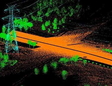
LiDAR Imaging
Light Detection and Ranging, or LiDAR, is a remote sensing method used to examine and measure Ohio topography as well as objects, like vegetation, upon it.
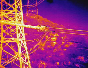
Infrared Imaging
Thermographic IR cameras are used to detect radiation in the long-infrared range of the electromagnetic spectrum and produce images of that radiation, called thermograms.
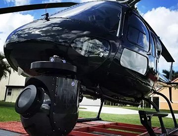
HD Video Gimbal Capture
Modern HD and 4K cameras can be mounted to helicopters, using the proper STCs, with a gimbal to stabilize photos & videos for detailed results.

Specialized Aerial Cinematography and Videography Services
For expert camera work in the Columbus Sky
Get a Fast, free QuoteColumbus Aerial Cinematography
Columbus Helicopter Charters facilitates access to a full spectrum of resources essential for professional-grade aerial cinematography across Ohio. We support custom production requirements by provisioning state-of-the-art gyro-stabilized camera platforms, including systems like Tyler Mounts, Wesscam, Cineflex, Pictorvision, and SpaceCam. These are compatible with a range of high-performance cameras, such as Cineflex HD, RED Epic, and Arri Alexa, alongside specialized 3D and experimental camera systems. Whether your production demands air-to-air or ground-to-air perspectives, we offer comprehensive support to achieve your specific visual objectives. The flight crews involved are experienced in collaborative operations, working meticulously with aerial Directors of Photography and production directors to deliver precise cinematographic outcomes. Specializing in both still and motion aerial photography, Columbus Helicopter Charters is equipped to support nearly every media-related operation within Ohio. This includes feature films, television productions, documentaries, promotional videos, commercials, complex aerial prop placements, rapid response coverage for television networks, and extensive visual documentation of historical events and major sporting spectacles, utilizing a diverse array of helicopter configurations to meet exacting production specifications.
Call Us Today at 1-866-826-4826 for a Free Quote
Contact Us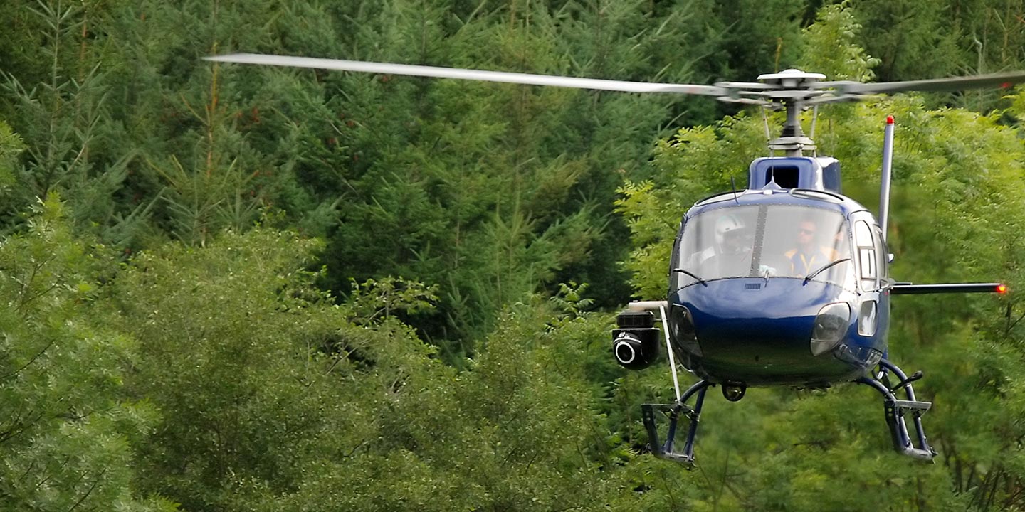
Aerial Photos
Hand-held or Mounted OpTions in Columbus
We will help you get the right equipment for your aerial photography project! Call 1-866-826-4826 today to get a fast, free quote.
The Most Options for Photography
For capturing definitive visual documentation of Ohio's diverse topography and infrastructure, aerial photography from a helicopter provides an unmatched vantage point. Columbus Helicopter Charters specializes in facilitating tailored aerial photography missions designed to meet rigorous client specifications for visual data acquisition. We ensure access to robust platforms for comprehensive photographic opportunities across Ohio. Many helicopter configurations allow for the safe removal of doors, providing an unobstructed field of view for handheld camera systems. For enhanced stability and precision imaging, we also provision access to advanced gyro-stabilized camera mounts, essential for achieving consistently sharp and professional-grade photographic results across challenging operational environments.
Superior Service
Every one of our customers gets a dedicated helicopter expert to assist with flight plans, tech loadouts, production logistics, project schedules, and other demands.
Over 500 Aircraft
Our network of direct air partners extends well beyond Columbus, Ohio. This allows us to offer a wide range of solutions for even the most sophisticated projects.
The Best Equipment
From high-tech sensors like LiDAR, FLIR, and GIS to HD cameras and movie production gimbals, we're here to make your job as easy as possible.